Original Antique Map China Korea Japan 19th Century East Asia Lapie


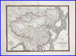
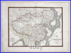
Original Antique Map - China - Korea - Japan - 19th Century - East Asia - Lapie. A fine first edition example of M. Lapie's 1832 map of the Chinese empire and Japan. The map covers all of China, Korea, and Japan from Asiatic Russia to India and the Sea of China and from Independent Tartary to the Pacific Ocean, just a few years prior to the Opium Wars.
As this map was printed, the weakening Qing, China's last imperial dynasty, dominated the region. Following the Napoleonic Wars of 1815, trade between China and europe increased dramatically, leading to hostility between the Qing regime and the european governments.
Increased demand for Chinese goods in europe and a distinct lack of interest in european goods in China led to a trade imbalance that began to deplete european raw materials. European merchants consequently introduced opium to china, ultimately leading to the Opium Wars of 1839. This map is also exceptionally interesting for its treatment of the Sea of Korea (Mer de Corea) and the Sea of Japan (Mer de Japon). Today both names are used to refer to the body of water between Korea and Japan. There is considerable academic dispute between the two nations over the proper name. Lapie curiously uses both names, defining the sea between Korea and Japan as the Sea of Japan and the sea between Korea and Taiwan (Formosa) as the Sea of Korea.This map was engraved by Armand Joseph Lallemand as plate no. 36 in the first edition of M. Lapie's important Atlas Universel.
This map, like all maps from the Atlas Universel features an embossed stamp from the Lapie firm. Many more antique maps and prints on dahlstromsfineart.
Size: 26" x 20" inches / 66 cm x 50 cm. Alexandre Emile Lapie & Pierre M. We provide a Certificate of Authenticity upon request. There is faint pigmentation throughout the map. We offers a tracking link to ensure peace of mind.
All our artworks are packaged to a very high standard, using protective decorative tissue paper and hardboard backing in a cardboard envelope. Sign up to our newsletter for special offers. Welcome to our Antique Print Shop we Are a Family run Gallery trading in Antique Prints, Maps, Drawings and Photographs. So all you see here in Our Store is all Original Pieces the date they carry is the actual date/year they were printed. Based in Sweden we are proud members of The Swedish Fine Art Print Society at The National Gallery, and been trading for the past 51 years, welcome to our Online Gallery.
Enjoy and have a Great Day! Listing and template services provided by inkFrog.
