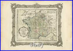
Antique Map of France at the beginning of the 17th Century by Zannoni (1765)


Add this shop to my favorites. Antique Map of France at the beginning of the 17th Century by Zannoni (1765). Availability: in stock Condition : Very good, please study image carefully.
Date : 1765 Overall size : 40 x 28 cm. Image size : 30 x 24 cm. Description: Antique map France titled'Carte pour servir à intelligence de l'Histoire de France..
Beautiful old map of France. This map originates from'Atlas Historique de la France Ancienne et Moderne' by M. Artists and Engravers: Published by S.