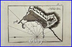
Antique Map Joseph Roux Harbour Plan Port of Ancona in Italy F5


Antique Map - Joseph Roux - Harbour Plan - Port of Ancona in Italy - F5. An old 18th century map created in France by the famous engraver and cartographer. This antique map shows the. Port of Ancona in Italy. The map shows depth measurements and anchorage points.
This chart was used on. In 1803 and 1805 and also on. Recueil des principaux planes des Ports et Rades de la Mer Mediterranee escraits.
25 cm x 15 cm. We offers a tracking link to ensure peace of mind. All our artworks are packaged to a very high standard, using protective decorative tissue paper and hardboard backing in a cardboard envelope.
Sign up to our newsletter for special offers. Welcome to our Antique Print Shop we Are a Family run Gallery trading in Antique Prints, Maps, Drawings and Photographs. So all you see here in Our Store is all Original Pieces the date they carry is the actual date/year they were printed. Based in Sweden we are proud members of The Swedish Fine Art Print Society at The National Gallery, and been trading for the past 51 years, welcome to our Online Gallery. Enjoy and have a Great Day! Listing and template services provided by inkFrog.