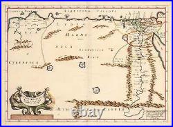
17th Century Antique map of the Patriarchate of Alexandria in Roman times, 1640


Dimensions: 14 x 19.75 inches (354.6 x 50.2 cm). This interesting map depicts the Patriarchate of Alexandria in Roman times. It covers the area between Benghazi and the Red Sea. Demographics of the region are depicted by the number of cities and towns concentrated in Egypt along the Nile and at its delta. The region's mountains and lakes are detailed.
A beautiful decorative cartouche featuring mermen embellishes the map in the lower left quadrant. Condition: This map is in A- condition with slight wrinkling at the centerfold.
