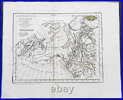
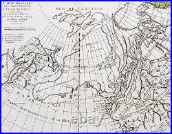
1772 Robert De Vaugondy & Diderot Antique Map of America California to Alaska


Carte Generale Des Decouvertes De L\'Amiral De Fonte representant la grande probabilite d\'un Passage au Nord Ouestg par Thomas Jefferys. De Vaugondy, Gilles Robert 1688 - 1766. 19in x 15 3/4in (480mm x 400mm).
This magnificent original copper-plate engraved antique map of the NW coast of America based upon the Thomas Jefferys map of 1768, by Robert De Vaugondy in 1772, by Robert De Vaugondy was engraved in 1772 - the date is engraved at the foot of the map - and published in the 1775 edition of Denis Diderots (1713-84) Encyclopédie, ou dictionnaire raisonné des sciences, des arts et des métiers (Encyclopedia, or a Systematic Dictionary of the Sciences, Arts, and Crafts). Denis Diderot 1713 - 1784 was a French philosopher, art critic, and writer, best known for serving as co-founder, chief editor, and contributor to the Encyclopédie along with Jean le Rond d Alembert. He was a prominent figure during the Enlightenment. Diderot began his education by obtaining a Master of Arts degree in philosophy at a Jesuit college in 1732.
He considered working in the church clergy before briefly studying law. When he decided to become a writer in 1734, his father disowned him for not entering one of the learned professions. He lived a bohemian existence for the next decade. He befriended philosopher Jean-Jacques Rousseau in 1742.
Though his work was broad as well as rigorous, it did not bring Diderot riches. He secured none of the posts that were occasionally given to needy men of letters; he could not even obtain the bare official recognition of merit that was implied by being chosen a member of the Académie française. She then requested that the philosopher retain the books in Paris until she required them, and act as her librarian with a yearly salary.
Between October 1773 and March 1774, the sick Diderot spent a few months at the empress\'s court in Saint Petersburg. Diderot died of pulmonary thrombosis in Paris on 31 July 1784, and was buried in the city\'s Église Saint-Roch. His heirs sent his vast library to Catherine II, who had it deposited at the National Library of Russia. He has several times been denied burial in the Panthéon with other French notables. The French government considered memorializing him in this fashion on the 300th anniversary of his birth, but this did not come to pass. Diderot\'s literary reputation during his lifetime rested primarily on his plays and his contributions to the Encyclopédie; many of his most important works, including Jacques the Fatalist, Rameaus Nephew, Paradox of the Actor, and D Alembert\'s Dream, were published only after his death. Paper thickness and quality: - Heavy and stable Paper color : - off white Age of map color: - Colors used: - General color appearance: - Paper size: - 19in x 15 3/4in (480mm x 400mm) Plate size: - 16in x 12 1/2in (410mm x 320mm) Margins: - Min 1in (25mm).Margins: - Folds as issued Plate area: - Light age toning along folds as issued, small loss to center fold Verso: - Re-enforced along fold. Background: Interesting map of the NW Coast of America and the NE Coast of Asia, based upon the Thomas Jefferys map of 1768.
Prior to Cooks 1st Voyage, the English, French and Russians were actively debating the cartography of the region in the North Pacific between Asia and North America. The Russian explorations of the first half of the 18th Century, including those by Behring, Tchirikow and others, had been reported by JN De L Isle, who had worked with the Russians and was privy to their latest discoveries. The mythical voyages of De Fuca, d Aguilar and De Font were still very much in evidence in contemporary cartography, as were concepts of a NW Passage, the Sea of the West, River of the West and other vestiges of 16th and 17th Century conjectural/mythical cartography. Following the publication by Buache of his maps on the region, the debate between the French and English was quite fertile, so much so that Diderot dedicated most of his 10 map supplments to the region. This map shows the Jefferys model, including a wide De Fuca based River from Puget Sound to the Atlantic over Hudson\'s Bay, several significant rivers flowing from the Pacific to the middle of North America, and Jesuit based water passages from the Pacific to the Arctic Seas. A marvelous approximation of Alaskan Archipelago is shown, along with the Russian discoveries. De Vaugondy, Gilles Robert 1688 - 1766 Didier Robert 1723 - 86 Gilles and Didier Robert De Vaugondy were father and son, respectively, and produced their atlas, globes and maps in concert. In many cases they did not use the initials of their first names when signing their maps, so it can be unclear at times who made a given map. On some maps fils or filio follows the name, designating its author as the son. In other instances, the authorship can be determined by the distinctive way each signed his maps: the father normally used \\\M. Robert, \\\" leaving off the last name, and the son, \\\"Robert de Vaugondy. \\\ The Atlas Universal [Paris, 1757] was one of the most important 18th century atlases and one of the great achievements of the French Enlightenment. The Vaugondy\\\'s employed strict standards for including maps in this atlas and in many cases subjected them to astronomically derived readings for latitude and longitude.Moreover, \\\'their frequent use of eighteenth century sources, often from the 1740s, provided their atlas with up-to-date information. While their preference was for maps that bad been surveyed in the field and maps published in the region itself, they did not hesitate to turn to older sources when more recent maps were found to be lacking. 61 For their maps of Canada and South America, the Vaugondy\\\'s had access to sources held by the Depot de la Marine, the official French repository for maritime-related information. Like Ortelius and Mercator before them, the Vaugondy`s listed the sources of their maps, which is of incalculable benefit to anyone seeking to understand not only their maps but also those of the period. \\\A feature of the maps of the Atlas Universel which attracted unanimous praise from critics was the cartouches.
64 A number of artisans worked on their design and engraving; several cartouches were engraved and signed by the Haussard sisters. Among the most pictorial cartouches are the four found on maps showing the postal routes of Great Britain, France, Germany, Spain and Portugal. They depict postal carriers en route in richly detailed settings. Please note all items auctioned are genuine, we do not sell reproductions. A Certificate of Authenticity (COA) can be issued on request.
What is an Antique Map. The word Antique in the traditional sense refers to an item that is more than a hundred years old. The majority of antique maps for sale today come from books or atlases and have survived due to the protection offered by the hardback covers.The first thing to determine when staring a collection or purchasing an item, is what is important to you. Most collectors prefer to build their collections around a theme. You may decide to collect maps from one region or country, charting its development through time. Similarly you could collect maps of one particular period in time, by type i. Sea or celestial charts or by cartographer.
The collector might also want to consider the theme of cartographical misconceptions such as California as an island or Australia as Terra Australis or the Great Southern Land. The subject is so wide that any would-be-collector has almost endless possibilities to find his own little niche within the field, and thereby build a rewarding collection. Starting a collection & pricing. Pricing is based on a number of different factors, the most important of which is regional. In any series of maps the most valuable are usually the World Map and the America/North America.
The World because it is usually the most decorative and America because it has the strongest regional market. Other factors that come into play re: price is rarity, age, size, historical importance, decorative value (colour) and overall condition and quality of paper it is printed on.
As specialised dealers, we frequently work with first time map buyers who are just starting their collection. Classical Images was founded 1998 and has built an excellent reputation for supplying high quality original antiquarian maps, historical atlases, antique books and prints. We carry an extensive inventory of antiquarian collectibles from the 15th to 19th century. Our collection typically includes rare books and decorative antique maps and prints by renowned cartographers, authors and engravers. Specific items not listed may be sourced on request.
Classical Images adheres to the Codes of Ethics outlined by the Antiquarian Booksellers Association of America (ABAA). We are a primarily an online based enterprise, however our inventory may be viewed by appointment.