1712 John Senex Large Antique Map of Europe Large Poland, Russia, Italy, Spain
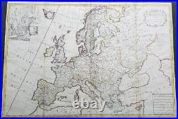
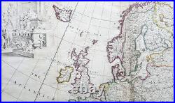

Europe Corrected from ye Observations Communicated to the Royal Society of London and Paris By John Senex, Geographer to The Queen. 35 1/2in x 26in (900mm x 660mm).
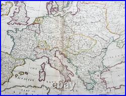
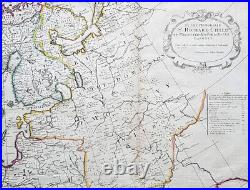
This extraordinary, rare very large & beautifully hand coloured original copper-plate engraved antique map of Europe - showing the Political Boundaries of the early 18th century - by John Senex was published in the 1712 edition of his large Elephant Folio General Atlas. The map is dedicated to Sir Richard Child of Wansted Ist Earl of Tynley and Essex. This map is in VG condition. These large scale maps are scarce due mainly to their size, with damage and loss over time inevitable.Paper thickness and quality: - Heavy and stable Paper color : - off white Age of map color: - Original Colors used: - Yellow, green, blue, pink General color appearance: - Authentic Paper size: - 35 1/2in x 26in (900mm x 660mm) Plate size: - 35 1/2in x 26in (900mm x 660mm) Margins: - Min 1/2in (12mm). Margins: - Several small repairs to margins Plate area: - Soiling to & several professional repairs to folds Verso: - Soiling. Background: A very interesting and scarce map of Europe at the beginning of the 18th century reflecting a continent before war and upheaval. The Ottoman Empire is still well entrenched stretching north to the southern borders of Austria & Hungary. Poland extends from the Baltic to the Black Sea encompassing much of SE Europe bordering Russia.
Germany and Italy are shown as large extended countries on the map but were in truth made up of many large and small parochial states and Kingdoms. Overall a fantastic large and fascinating map entering a century of great upheaval. Publisher and engraver, Senex, was a contemporary of the cartographer Herman Moll and no doubt, to some extent, a rival although his output was rather smaller.
In conjunction with Charles Price and James Maxwell he produced some fine maps of the world and the continents as well as loose maps of various countries (1708-14). Apart from these maps he seems to have had a particular interest in road maps and in 1719 he issued a corrected edition of Ogilby\\\'s Britannia in miniature with updated road maps of England and Wales. Please note all items auctioned are genuine, we do not sell reproductions.
A Certificate of Authenticity (COA) can be issued on request. What is an Antique Map.
The word Antique in the traditional sense refers to an item that is more than a hundred years old. The majority of antique maps for sale today come from books or atlases and have survived due to the protection offered by the hardback covers. The first thing to determine when staring a collection or purchasing an item, is what is important to you. Most collectors prefer to build their collections around a theme. You may decide to collect maps from one region or country, charting its development through time.
Similarly you could collect maps of one particular period in time, by type i. Sea or celestial charts or by cartographer. The collector might also want to consider the theme of cartographical misconceptions such as California as an island or Australia as Terra Australis or the Great Southern Land. The subject is so wide that any would-be-collector has almost endless possibilities to find his own little niche within the field, and thereby build a rewarding collection.Starting a collection & pricing. Pricing is based on a number of different factors, the most important of which is regional. In any series of maps the most valuable are usually the World Map and the America/North America. The World because it is usually the most decorative and America because it has the strongest regional market. Other factors that come into play re: price is rarity, age, size, historical importance, decorative value (colour) and overall condition and quality of paper it is printed on.
As specialised dealers, we frequently work with first time map buyers who are just starting their collection. Classical Images was founded 1998 and has built an excellent reputation for supplying high quality original antiquarian maps, historical atlases, antique books and prints.
We carry an extensive inventory of antiquarian collectibles from the 15th to 19th century. Our collection typically includes rare books and decorative antique maps and prints by renowned cartographers, authors and engravers.
Specific items not listed may be sourced on request. Classical Images adheres to the Codes of Ethics outlined by the Antiquarian Booksellers Association of America (ABAA).We are a primarily an online based enterprise, however our inventory may be viewed by appointment.
