1634 Joan Blaeu Large Antique Map of Europe under Charlemagne I, 8th Century
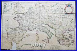
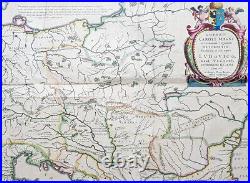
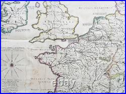
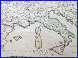
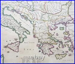

Imperii Caroli Magni et vicinarum regionum Descriptio Dedieata et inferipta Ludovico... 39 1/2in x 26 1/2in (1.00mm x 670mm). This large superbly hand coloured original copper plate engraved, 4 x sheet, antique map of Europe, as it was under Charlemagne I, was originally published by the 16th century cartographer Petrus Bertius and later re-engraved and published in the 1634 German edition of Joan Blaeus Atlas Novus. The map has been damaged at the bottom left sheet, with image missing.
As this is a large folding map, the folds, sometime in the past, have been re-enforced and refolded. A large four sheet historical map showing the empire of Charlemagne, aka Carolus Magnus, aka Charles the Great. Charlemagne ruled in the 8th century and is regarded as the founding father of both France and Germany. Blaeu credits Petrus Bertius for the cartography.
He was also cartographer and a prolific writer on historical and theological subjects. The map shows the majority of Europe, from southeastern Ireland south to Gibraltar and westward to Germany and Greece. Paper thickness and quality: - Heavy and stable Paper color : - off white Age of map color: - Original Colors used: - Yellow, green, blue, pink General color appearance: - Authentic Paper size: - 39 1/2in x 26 1/2in (1.00mm x 670mm) Plate size: - 39in x 26in (980mm x 660mm) Margins: - Min 0in (0mm).Margins: - Bottom left corner margins lost Plate area: - Folds as issued, bottom 4in x 2in section missing. Light soiling Verso: - Folds re-enforced on verso. Background: Charlemagne 742 - 814, numbered Charles I, was king of the Franks from 768, king of the Lombards from 774, and emperor of the Romans from 800. He united much of western and central Europe during the Early Middle Ages.
He was the first recognised emperor to rule from western Europe since the fall of the Western Roman Empire three centuries earlier. The expanded Frankish state that Charlemagne founded is called the Carolingian Empire. He was later canonized by Antipope Paschal III. Charlemagne was the eldest son of Pepin the Short and Bertrada of Laon, born before their canonical marriage.
He became king in 768 following his fathers death, initially as co-ruler with his brother Carloman I. Carlomans sudden death in December 771 under unexplained circumstances left Charlemagne as the sole ruler of the Frankish Kingdom. He continued his fathers policy towards the papacy and became its protector, removing the Lombards from power in northern Italy and leading an incursion into Muslim Spain.
He campaigned against the Saxons to his east, Christianizing them upon penalty of death and leading to events such as the Massacre of Verden. He reached the height of his power in 800 when he was crowned Emperor of the Romans by Pope Leo III on Christmas Day at Romes Old St. Charlemagne has been called the Father of Europe (Pater Europae), as he united most of Western Europe for the first time since the classical era of the Roman Empire and united parts of Europe that had never been under Frankish or Roman rule. His rule spurred the Carolingian Renaissance, a period of energetic cultural and intellectual activity within the Western Church. Emperors of the Holy Roman Empire considered themselves successors of Charlemagne, as did the French and German monarchs.
However, the Eastern Orthodox Church views Charlemagne more controversially, labelling as heterodox his support of the filioque and the Popes recognition of him as legitimate Roman Emperor rather than Irene of Athens of the Byzantine Empire. These and other machinations led to the eventual split of Rome and Constantinople in the Great Schism of 1054. Charlemagne died in 814, having ruled as emperor for almost 14 years and as king for almost 46 years. He was laid to rest in his imperial capital city of Aachen.He married at least four times and had three legitimate sons, but only his son Louis the Pious survived to succeed him. At this propitious time in the history of the Northern Provinces, Willem Janszoon Blaeu, who was born at Alkmaar in 1571 and trained in astronomy and the sciences by Tycho Brahe, the celebrated Danish astronomer, founded a business in Amsterdam in 1599 as a globe and instrument maker.
It was not long before the business expanded, publishing maps, topographical works and books of sea charts as well as constructing globes. His most notable early work was a map of Holland (1604), a fine World Map (1605-06) and Het Licht der Zeevaerdt (The Light of Navigation), a marine atlas, which went through many editions in different languages and under a variety of titles. At the same time Blaeu was planning a major atlas intended to include the most up-to-date maps of the whole of the known world but progress on so vast a project was slow and not until he bought between 30 and 40 plates of the Mercator Atlas from Jodocus Hondius II to add to his own collection was he able to publish, in 1630, a 60-map volume with the title Atlantis Appendix. It was another five years before the first two volumes of his planned world atlas, Atlas Novus or the Theatrum Orbis Terrarum were issued. About this time he was appointed Hydrographer to the East India Company. In 1638 Blaeu died and the business passed into the hands of his sons, Joan and Cornelis, who continued and expanded their father\\\'s ambitious plans.After the death of Cornelis, Joan directed the work alone and the whole series of 6 volumes was eventually completed about 1655. As soon as it was finished he began the preparation of the even larger work, the Atlas Major, which reached publication in 1662 in II volumes (later editions in 9-12 volumes) and contained nearly 6oo double-page maps and 3,000 pages of text. This was, and indeed remains, the most magnificent work of its kind ever produced; perhaps its geographical content was not as up-to-date or as accurate as its author could have wished, but any deficiencies in that direction were more than compensated for by the fine engraving and colouring, the elaborate cartouches and pictorial and heraldic detail and especially the splendid calligraphy. In 1672 a disastrous fire destroyed Blaeu\\\'s printing house in the Gravenstraat and a year afterwards Joan Blaeu died. The firm\\\'s surviving stocks of plates and maps were gradually dispersed, some of the plates being bought by F.
De Wit and Schenk and Valck, before final closure in about 1695. It ought to be mentioned here that there is often confusion between the elder Blaeu and his rival Jan Jansson (Johannes Janssonius). Up to about 1619 Blaeu often signed his works Guilielmus Janssonius or Willems Jans Zoon but after that time he seems to have decided on Guilielmus or G. Please note all items auctioned are genuine, we do not sell reproductions.
A Certificate of Authenticity (COA) can be issued on request. What is an Antique Map. The word Antique in the traditional sense refers to an item that is more than a hundred years old. The majority of antique maps for sale today come from books or atlases and have survived due to the protection offered by the hardback covers. The first thing to determine when staring a collection or purchasing an item, is what is important to you. Most collectors prefer to build their collections around a theme.You may decide to collect maps from one region or country, charting its development through time. Similarly you could collect maps of one particular period in time, by type i. Sea or celestial charts or by cartographer. The collector might also want to consider the theme of cartographical misconceptions such as California as an island or Australia as Terra Australis or the Great Southern Land.
The subject is so wide that any would-be-collector has almost endless possibilities to find his own little niche within the field, and thereby build a rewarding collection. Starting a collection & pricing. Pricing is based on a number of different factors, the most important of which is regional. In any series of maps the most valuable are usually the World Map and the America/North America. The World because it is usually the most decorative and America because it has the strongest regional market.
Other factors that come into play re: price is rarity, age, size, historical importance, decorative value (colour) and overall condition and quality of paper it is printed on. As specialised dealers, we frequently work with first time map buyers who are just starting their collection.
Classical Images was founded 1998 and has built an excellent reputation for supplying high quality original antiquarian maps, historical atlases, antique books and prints. We carry an extensive inventory of antiquarian collectibles from the 15th to 19th century. Our collection typically includes rare books and decorative antique maps and prints by renowned cartographers, authors and engravers. Specific items not listed may be sourced on request. Classical Images adheres to the Codes of Ethics outlined by the Antiquarian Booksellers Association of America (ABAA). We are a primarily an online based enterprise, however our inventory may be viewed by appointment.