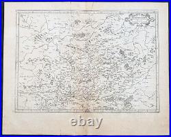
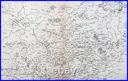
1628 Gerard Mercator Antique Map of The Burgundy Region of France


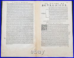
21in x 17in (530mm x 430mm). This original copper plate engraved antique map of of the historical region of the Free County of Burgundy (Franche Comte de Bourgogne) of eastern France by Gerard Mercator was published by Henricus Hondius in the early 1628 French edition of Gerard Mercators Atlas. These maps, published in the early editions of Mercators atlas, are the original maps drawn and engraved by Gerald Mercator in the mid to late 16th century, published by his son Rumold as an atlas, after his death, in 1595. Paper thickness and quality: - Heavy and stable Paper color : - off white Age of map color: - Colors used: - General color appearance: - Paper size: - 21in x 17in (530mm x 430mm) Plate size: - 20in x 15in (510mm x 380mm) Margins: - Min 1/2in (12mm).
Margins: - Age toning, light creasing Plate area: - Age toning, light creasing Verso: - Age toning, light creasing. Background: Burgundy is a historical territory and a former administrative region of France.
It takes its name from the Burgundians, an East Germanic people who moved westwards beyond the Rhine during the late Roman period. Historically, Burgundy has referred to numerous political entities, including kingdoms and duchies spanning territory from the Mediterranean to the Low Countries. The first recorded inhabitants of the area that became Burgundy were Celts, who were eventually incorporated in the Roman Empire as Gallo-Romans. During the 4th century, the Burgundians, a Germanic people, who may have originated in Bornholm (on the Baltic Sea), settled in the western Alps. They founded the Kingdom of the Burgundians, which was conquered in the 6th century by another Germanic tribe, the Franks.
Later, the region was divided between the Duchy of Burgundy (to the west) and the Free County of Burgundy (to the east). The Duchy of Burgundy is the better-known of the two, later becoming the French province of Burgundy, while the County of Burgundy became the French province of Franche-Comté, literally meaning free county. Burgundys modern existence is rooted in the dissolution of the Frankish Empire. In the 880s, there were four Burgundies, which were the Kingdom of Upper and Lower Burgundy, the duchy and the county. During the Middle Ages, Burgundy was home to some of the most important Western churches and monasteries, including those of Cluny, Cîteaux, and Vézelay. Cluny, founded in 910, exerted a strong influence in Europe for centuries.The first Cistercian abbey was founded in 1098 in Cîteaux. Over the next century, hundreds of Cistercian abbeys were founded throughout Europe, in a large part due to the charisma and influence of Bernard of Clairvaux.
The Abbey of Fontenay, a UNESCO World Heritage site, is today the best-preserved Cistercian abbey in Burgundy. The Abbey of Vezelay, also a UNESCO site, is still a starting point for pilgrimages to Santiago de Compostela. Cluny was almost totally destroyed during the French Revolution. During the Hundred Years War, King John II of France gave the duchy to his youngest son, Philip the Bold. The duchy soon became a major rival to the crown. The court in Dijon outshone the French court both economically and culturally. In 1477, at the battle of Nancy during the Burgundian Wars, the last duke Charles the Bold was killed in battle, and the Duchy itself was annexed by France and became a province. However the northern part of the empire was taken by the Austrian Habsburgs. With the French Revolution in the end of the 18th century, the administrative units of the provinces disappeared, but were reconstituted as regions during the Fifth Republic in the 1970s. The modern-day administrative region comprises most of the former duchy. Mercator, Gerard 1512-94 For nearly sixty years, during the most important and exciting period in the story of modern map making, Gerard Mercator was the supreme cartographer, his name, second only to Ptolemy, synonymous with the form of map projection still in use today. Although not the inventor of this type of projection he was the first to apply it to navigational charts in such a form that compass bearings could be plotted on charts in straight lines, thereby providing seamen with a solution to an age-old problem of navigation at sea. His influence transformed land surveying and his researches and calculations led him to break away from Ptolemy\\\'s conception of the size and outline of the Continents, drastically reducing the longitudinal length of Europe and Asia and altering the shape of the Old World as visualized in the early sixteenth century. Mercator was born in Rupelmonde in Flanders and studied in Louvain under Gemma Frisius, Dutch writer, astronomer and mathematician. He established himself there as a cartographer and instrument and globe maker, and when he was twenty-five drew and engraved his first map (of Palestine) and went on to produce a map of Flanders (1540) supervising the surveying and completing the drafting and engraving himself. The excellence of his work brought him the patronage of Charles V for whom he constructed a globe, but in spite of his favor with the Emperor he was caught up in the persecution of Lutheran Protestants and charged with heresy, fortunately without serious consequences. No doubt the fear of further persecution influenced his move in 1552 to Duisburg, where he continued the production of maps, globes and instruments culminating in large-scale maps of Europe (1554), the British Isles (1564) and the famous World Map on 18 sheets drawn to his new projection (1569). All these early maps are exceedingly rare, some being known by only one copy. In later life he devoted himself to his edition of the maps in Ptolemy\\\'s Geographia, reproduced in his own engraving as nearly as possible in their original form, and to the preparation of his 3-volume collection of maps to which, for the first time, the word \\\'Atlas\\\' was applied. The word was chosen, he wrote, \\\'to honor the Titan, Atlas, King of Mauritania, a learned philosopher, mathematician, and astronomer\\\'.The first two parts of the Atlas were published in 1585 and 1589 and the third, with the first two making a complete edition, in 1595 the year after Mercator\\\'s death. Mercator\\\'s sons and grandsons were all cartographers and made their contributions in various ways to the great atlas. Rumold, in particular, was responsible for the complete edition in 1595.
After a second complete edition in 1602, the map plates were bought in 1604 by Jodocus Hondius who, with his sons, Jodocus II and Henricus, published enlarged editions which dominated the map market for the following twenty to thirty years. Please note all items auctioned are genuine, we do not sell reproductions. A Certificate of Authenticity (COA) can be issued on request. What is an Antique Map. The word Antique in the traditional sense refers to an item that is more than a hundred years old.
The majority of antique maps for sale today come from books or atlases and have survived due to the protection offered by the hardback covers. The first thing to determine when staring a collection or purchasing an item, is what is important to you. Most collectors prefer to build their collections around a theme. You may decide to collect maps from one region or country, charting its development through time. Similarly you could collect maps of one particular period in time, by type i.
Sea or celestial charts or by cartographer. The collector might also want to consider the theme of cartographical misconceptions such as California as an island or Australia as Terra Australis or the Great Southern Land. The subject is so wide that any would-be-collector has almost endless possibilities to find his own little niche within the field, and thereby build a rewarding collection. Starting a collection & pricing. Pricing is based on a number of different factors, the most important of which is regional.
In any series of maps the most valuable are usually the World Map and the America/North America. The World because it is usually the most decorative and America because it has the strongest regional market.Other factors that come into play re: price is rarity, age, size, historical importance, decorative value (colour) and overall condition and quality of paper it is printed on. As specialised dealers, we frequently work with first time map buyers who are just starting their collection. Classical Images was founded 1998 and has built an excellent reputation for supplying high quality original antiquarian maps, historical atlases, antique books and prints.
We carry an extensive inventory of antiquarian collectibles from the 15th to 19th century. Our collection typically includes rare books and decorative antique maps and prints by renowned cartographers, authors and engravers. Specific items not listed may be sourced on request. Classical Images adheres to the Codes of Ethics outlined by the Antiquarian Booksellers Association of America (ABAA). We are a primarily an online based enterprise, however our inventory may be viewed by appointment.
